Hélèna Katz is a writer who lives, works and plays in Thebacha, on the lands of the Salt River First Nation, Smith’s Landing First Nation and the Northwest Territory Métis Nation. She is the author of four nonfiction books, hundreds of magazine articles and one audiobook. Going for long walks keeps her grounded and connected to her creativity.
Thebacha / Fort Smith: Playing outside
By Hélèna Katz (Images supplied by the NWT Archives)
A bear is poking around in the grass beside the highway in Wood Buffalo National Park heading towards Fort Smith, looking for some lunch. Further along, bison stand around in small groups like construction workers on a coffee break. On a good day, the 270-kilometre drive between Hay River and Fort Smith can be a nine-bear trip with a few burly bison thrown in. At the Salt Plains closer to Fort Smith, the large prints of a bison dwarf the bare human toes of a visitor wandering along the dry, cracked ground at the base of an escarpment. On the right, a pile of white salt is a reminder that this was once an ancient seabed.
Fort Smith is a pretty community on the 60th Parallel that was carved into the heart of the boreal forest along the banks of the Slave River. The Dene First Nations people travelled along the Slave River in harmony with the seasons. Then fur traders began using the river as a highway from Lake Athabasca to Great Slave Lake and down the Mackenzie River to the Arctic Ocean.
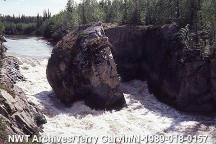
Four sets of impassable rapids were the only obstacle along the way. Travellers pulled their boats out of the water at Fort Fitzgerald, Alberta, and portaged them for about 27 kilometres around the rapids before putting them back in the water at Bell Rock, just past where Fort Smith now sits. Hence, the community’s Chipewyan name Thebacha, which means “beside the rapids.” Most of the town’s 2,500 residents are members of the Smith’s Landing First Nation, Salt River First Nation or the Northwest Territory Métis Nation). Multilingual stop signs around town reflect the community’s Cree, Chipewyan, English and French heritage.
Owing to its geographic location and a highway that weaves back and forth along the border between Alberta and the Northwest Territories, community members and visitors can hopscotch between the two jurisdictions as they head outside to play on land and water throughout the year.
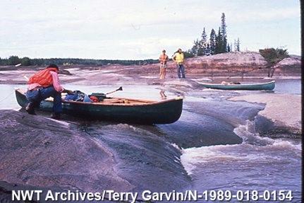
The most northerly colony of white pelicans nest on rocky islands in the middle of the Slave River. The Beach Boys song Surfin’ Safari plays in my head as two pelicans ride the waves like surfboards just off shoreat Rapids of the Drowned at a spot known locally as The Rocks. Each August long weekend, paddlers from as far away as the United States and Australia gather further along the river at Mountain Portage for Paddlefest – a celebration of whitewater activities. A portion of the Slave River is also linked to the TransCanada Trail.
In a strange quirk of geography part of the territorial border runs just south of Fort Smith, cutting acrossa highway that travels past the golf course, the ski club, hiking trails to three of the Slave River’s rapids down to the tiny settlement of Fort Fitzgerald on the lands of the Smith Landing First Nation, as well as access toWood Buffalo National Park and – all in northern Alberta. Some of the best spots to play are south of the territorial border.
Drive down Pine Lake Road into Canada’s largest national park and the world’s largest Dark Sky Preserve. Hop out at the Grosbeak Lake trailhead. After a 20-minute hike through the forest, the trees give way to the Mars-like landscape of the salt flats at Grosbeak. Visitors wander between porous orange rocks and streaks of rust-coloured mud intertwined with encrusted salt. It’s here that the delicate prints of a sandhill crane cross the lumbering tracks of a bear. Further down Pine Lake Road, a beach with aquamarine water looks like it was transported from a Caribbean resort and plopped down in the middle of the boreal forest.
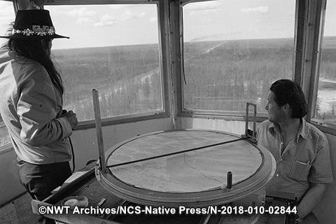
Across from the water, visitors pull into an open area beside two former warden cabins for the annual Thebacha and Wood Buffalo Dark Sky Festival. After enjoying astronomy activities at the Roberta Bondar Northern Observatory at the Fort Smith Star Park near the airport in town, participants are ready for more stargazing at the national park’s Sky Circle.
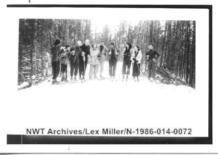
Once snow hits the ground, some residents trade their paddles and hiking boots for cross-country skis.Every winter since 1973, the Fort Smith Ski Club hosts the 30-km Thebacha Loppet from Fort Fitzgerald to Fort Smith. Cross-country skiers follow the First Nations’ portage route around the Slave River rapids during Western Canada’s oldest event of this nature.
In Fort Smith’s Bell Rock subdivision bookending the other side of the rapids, residents can head out onto their own trails on the south side of the highway. “The trail is tracked as of this afternoon,” a neighbour announces in the neighbourhood’s Facebook group. Others head off on foot along trails packed down by snowmobiles. In Thebacha, the former administrative centre of the Northwest Territories, recreation starts with heading outdoors.